What Is a Labeled World Map?
A world map labeled with continents and oceans is a detailed visual representation of the Earth’s surface. It highlights the major landmasses (continents) and water bodies (oceans), offering a bird’s eye view of our planet’s geography.
Whether you’re a student, traveler, or geography lover, this type of map helps you understand:
-
Where continents are located
-
Which oceans surround them
-
How regions are connected
List of Continents and Oceans on a World Map
Let’s begin with a quick summary in table form:
| Continent | Key Features | Largest Country |
|---|---|---|
| Asia | Largest, most populous | China |
| Africa | Rich in wildlife and resources | Algeria |
| North America | Economic hub, home to USA & Canada | Canada |
| South America | Lush rainforests like Amazon | Brazil |
| Antarctica | Icy desert, uninhabited by humans permanently | N/A |
| Europe | Historically significant and compact | Russia (European part) |
| Australia | Island continent, unique biodiversity | Australia |
| Ocean | Size Rank | Interesting Fact |
|---|---|---|
| Pacific Ocean | 1st | Largest, deepest, spans Asia to the Americas |
| Atlantic Ocean | 2nd | Separates Europe/Africa from Americas |
| Indian Ocean | 3rd | Warmest, between Africa, Asia, and Australia |
| Southern Ocean | 4th | Encircles Antarctica |
| Arctic Ocean | 5th | Smallest and coldest, near North Pole |
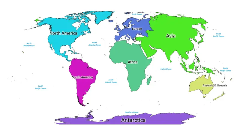
Labeled World Map (Visual Guide)
This high-quality labeled map below shows all the continents and oceans.
Image inserted here (image will appear shortly above)
Color-coded continents
Clearly marked oceans
Readable text and directional markers
Use this visual to instantly locate Asia, Africa, or the Pacific Ocean — ideal for students and educators!
Why Are Labeled World Maps Important?
A labeled world map does more than show names. It builds perspective. Here’s why they’re important:
-
Educational Value:
Perfect for classrooms and homeschooling. -
Navigation and Travel:
Helps in understanding global positioning and time zones. -
Environmental Awareness:
Visualizes where major ecosystems and climate zones exist. -
Geopolitical Insight:
Learn which nations share borders and oceans.
Understanding the Relationship Between Continents & Oceans
Here’s a breakdown without a table for easy reading:
-
Asia is bordered by the Arctic Ocean (north), Pacific Ocean (east), and Indian Ocean (south).
-
Africa touches the Atlantic on the west and Indian Ocean on the east.
-
North America is flanked by the Arctic (north), Atlantic (east), and Pacific (west).
-
South America lies between the Atlantic (east) and Pacific (west).
-
Europe, though part of Eurasia, is bordered by the Arctic and Atlantic Oceans.
-
Australia lies in the southern hemisphere, surrounded mainly by the Indian and Pacific Oceans.
-
Antarctica is encircled entirely by the Southern Ocean.
Fun Facts About the Map
-
The Pacific Ocean is bigger than all landmasses combined.
-
Asia covers 30% of the Earth’s land area.
-
Antarctica has 70% of the world’s freshwater (locked in ice).
Download High-Quality Printable Map
You can download a printable world map labeled with continents and oceans directly from:
-
[WorldMapQuest.com – Our Custom Map Section] (Coming Soon)
FAQs
1. What is a labeled world map?
A labeled world map displays the names and positions of all the continents and oceans, making it easier to study geography and understand Earth’s layout.
2. How many continents does a world map show?
A world map labels seven continents: Asia, Africa, North America, South America, Antarctica, Europe, and Australia.
3. How many oceans are labeled on a world map?
A modern labeled world map shows five oceans: Pacific, Atlantic, Indian, Southern, and Arctic Ocean.
4. Where can I download a labeled world map?
You can download high-resolution maps from educational websites like:
-
WorldMapQuest.com (Your site — Add download section here)
5. Why do labeled maps help students learn effectively?
Labeled maps help students and learners easily identify landmasses and water bodies. They build spatial awareness and improve memory retention for global geography.
6. Is the Southern Ocean a new addition to maps?
The National Geographic Society officially recognized the Southern Ocean in 2021, though scientists had referred to it for decades.
7. Can I use a labeled world map for educational projects?
Absolutely! Labeled world maps are perfect for school assignments, classroom posters, quizzes, and geography presentations.
Final Thoughts
A world map labeled with continents and oceans is not just a learning resource — it’s a passport to understanding Earth’s layout, scale, and diversity.
Make sure to bookmark this article and share it with fellow geography enthusiasts. And if you’re building an educational platform like WorldMapQuest.com, this is the kind of content that drives traffic, engagement, and SEO results.