Introduction:
What if you could time-travel using just your computer or smartphone? With historical maps and Google Earth features, you can do just that. These interactive tools allow users to overlay old maps onto today’s world, offering a visual journey into history.
Whether you’re curious about how cities evolved, tracking ancient trade routes, or researching colonial maps, Google Earth’s historical layers open doors to the past like never before.
What Are Historical Maps in Google Earth?
Historical maps Google Earth are georeferenced overlays of old maps and satellite imagery. These maps provide snapshots of Earth’s surface at different times. Google Earth allows users to explore satellite imagery dating back several decades, while curated historical maps from archives provide glimpses into even earlier centuries.
How to Access Historical Maps in Google Earth
Google Earth offers a simple way to view past imagery. Here’s how:
Step-by-Step Access:
-
Open Google Earth Pro (Free download on PC/Mac)
-
Search a location
-
Click the clock icon in the toolbar to activate the Historical Imagery slider.
-
Drag the timeline slider to view satellite imagery from past years.
-
For older maps, use map overlays or import KMZ/KML files from external archives.
Why Use Historical Maps?
Historical maps are more than just visuals — they’re storytelling tools. They offer valuable insights for:
| Use Case | Description |
|---|---|
| Academic Research | Useful for geography, history, archaeology, and environmental studies |
| Urban Development | Compare land usage, deforestation, and urban growth over decades |
| Genealogy & Ancestry | Track migration, property ownership, and ancestral towns |
| Natural Disaster Analysis | Examine changes in coastlines, flood zones, and earthquake regions |
| Tourism & Education | Enrich learning with visual, interactive historical journeys |
Best Historical Map Layers You Can Use on Google Earth
Below are popular historical map sources and overlays compatible with Google Earth:
| Historical Map Layer | Description | Source |
|---|---|---|
| Rumsey Historical Maps Collection | 120,000+ high-resolution historical maps with Google Earth overlays | DavidRumsey.com |
| WWII Battle Maps | Georeferenced battlefields and strategies from WWII | National Archives / KMZ community |
| Historic Aerials (USA) | Aerial photos from the 1930s to the present for urban studies | HistoricAerials.com |
| Old City Maps (London, Paris, NY, etc.) | Overlay 18th–20th century city maps on modern geography | New York Public Library / British Library |
| Google Earth Time Slider Imagery | Satellite imagery from 1984 onwards | Built-in feature of Google Earth Pro |
Tips for Using Historical Maps in Google Earth for Maximum Effect
-
Zoom In Slowly: Details appear clearer as you zoom in on historical overlays.
-
Adjust Opacity: Use the transparency slider to compare old maps with modern ones.
-
Combine with Street View: For city maps, Street View provides context to map details.
-
Use Layers Together: Overlay multiple maps to track progressive changes.
Educational Benefits of Historical Maps
Teachers and students can use these tools in classrooms for interactive learning:
-
Visualize World War II movements
-
See how borders have changed over time
-
Understand environmental impacts like deforestation or urbanisation
Many teachers now include historical map and Google Earth as a project tool to make history come alive.
Where to Find Free Historical Maps for Google Earth
If you’re looking for ready-to-import historical maps, here are some trusted sources:
-
David Rumsey Map Collection – Offers overlays and KML downloads
-
Old Maps Online – Filter historical maps by year and region
-
Google Earth Library – Open-source KMZ/KML files for educational use
-
USGS Earth Explorer – Excellent for old topographic maps
-
NASA Earth Observing System Data and Information System (EOSDIS) – Satellite imagery for environmental studies
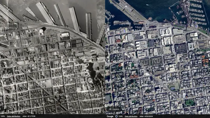
Use Case: Urban Growth in New York City
Here’s a real-world example of using historical maps in Google Earth for urban development research:
| Year | Observation |
|---|---|
| 1940s | Low-rise buildings, scattered urban layout |
| 1970s | Skyrocketing real estate, new roadways |
| 2000s | Dense skyscrapers, expanded metro lines |
Using the historical time slider, researchers can see how NYC’s skyline transformed over the decades.
Common Challenges When Using Historical Maps on Google Earth
While historical mapping is powerful, it comes with a few limitations:
-
Accuracy: Old maps may lack precision due to poor original surveying.
-
Availability: Not all regions have comprehensive historical imagery.
-
File Format Confusion: Many overlays require KMZ/KML, which beginners may not understand.
-
Performance: Large overlays can slow down Google Earth on low-end systems.
Alternatives and Enhancements
Want even more from your historical map exploration?
-
QGIS (Quantum GIS): Advanced GIS tool for map overlays
-
ArcGIS StoryMaps: Combine maps with storytelling elements
-
TimeMap of World History: Interactive maps by timeline and events
-
CesiumJS: Open-source 3D globe for developers
These tools complement historicals maps, Google Earth, and offer additional control for professional users.
Conclusion
Historical maps Google Earth offer a magical glimpse into the past using modern tools. From studying ancient cities to analysing environmental change, this free feature transforms how we understand time, place, and history.
Whether you’re an educator, researcher, or just a map enthusiast, using historical maps in Google Earth brings a new level of insight and discovery. Ready to explore the past?
Visit WorldMapQuest.com for more map-based tools, historical overlays, and global geography insights!
FAQs:
1. Can I view maps from the 1800s on Google Earth?
Yes, but through external overlays like the Rumsey Map Collection, not standard satellite imagery.
2. Is Google Earth Pro free to use?
Yes, it’s free to download and gives access to historical imagery tools.
3. Can I import custom historical maps into Google Earth?
Yes, using KMZ or KML formats.
4. Are historical maps accurate?
They offer valuable insights but may not be as precise as modern satellite maps.
5. What’s the best site for historical maps?
DavidRumsey.com and OldMapsOnline.org are highly recommended.